![[{[item.product.name]}]]([{[item.product.photo.url]}] 75w)


Mapa kieszonkowa - Tatry, Zakopane laminowana
Rodzaj: foliowana mapa kieszonkowa Skala: mapa Tatr -1:55'000, plan Zakopanego - 1:18'000 Rok wydania: 2023 Wydanie: 11 Format: 42 x 30 cm Jest to mapa kieszonkowa, foliowana (trwała i odporna na wilgoć) w skali 1:55'000. Wymiary mapy po złożeniu to zaledwie 10,5 x 15 cm. Przedstawia najbardziej znane i najczęściej odwiedzane góry w Polsce - Tatry. Zasięg mapy wyznaczają: Poronin na północy, Wołowiec na zachodzie, Rysy na południu i Łysa Polana na wschodzie. Obszar mapy obejmuje polskie Tatry Zachodnie i Tatry Wysokie. Na drugiej stronie mapa zawiera plan Zakopanego w skali 1:18'000 ze spisem ulic. Na mapie zaznaczono: szlaki turystyczne piesze wraz z czasami przejść, trasy spacerowe, trasy narciarskie, wyciągi narciarskie, miejsca postoju dorożek, schroniska górskie oraz ważniejsze atrakcje turystyczne.
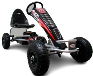
Safety Information
For use under direct adult supervision, Need to use protective measures. Do not use in traffic, Not suitable for children under the specified age. For use under adult supervision, This toy does not offer protection, Includes a toy. Adult supervision recommended
It has the CE mark confirming compliance with the requirements of the European Union directive for this type of device.
CE Declaration of Conformity | Complies with EN-71 - Safety of toys
For children over 3 years of age
It has the CE mark confirming compliance with the requirements of the European Union directive - Compliant with the EN-71 standard - Safety of toys